I'm not sure if it's because I grew up in a place where one's livelihood depended entirely upon the earth, but I've always found it interesting, even necessary, to know what was going on beneath my feet. What is the earth, the stuff where I'm standing, made of and what forces over the long history of the Earth shaped it?
In the weeks ending March and beginning April, I had the opportunity to explore the geology of the Philippines. I learned that most of the over 7000 islands of the Philippines were created through tectonic collisions and geological pressures that are still working themselves out. With the exception of the westernmost island of Palawan and its neighbors, the Philippine islands are made of what was once seabed, marine limestone and coral pushed to the surface, and most importantly, fertile volcanic lava and ash. These islands make up the Philippine Mobile Belt.
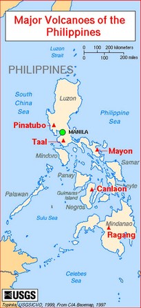
Ten million years ago during the Miocene era, pressures between the Eurasian Plate and Philippine Sea plates (and many, many plates within) resulted in volcanic activity which aided the formation of fertile islands, a process which continues today with 21 active volcanoes--five of which are on the most active and closely monitored list. Along with Indonesia and Japan, the volcanoes of the the Philippines make the Pacific Ring of Fire--one of the most active volcanic and seismic regions in the world. In early April we visited the two most active volcanoes in the Philippines: Mayon and Taal.
Before Easter, Joseph and I were in Legazpi City in the Bicol region of southern Luzon, home of Mount Mayon. This majestic wonder looms large in the Albay province and its nearly perfect cone shape has made it world-famous. Mayon is stratovolcanic, which means when it erupts it spews both lava and gases mixed with volcanic fragments, crystals, ash, pumice, and glass shards. Its most recent major eruption was in 2006, and while we didn't see any lava flow while we were there, gasses were coming out of the top. Of course, the top was hard to spot as it has a significant impact on the weather patterns and is often shrouded with clouds. "He's being shy," the locals like to say.
In the weeks ending March and beginning April, I had the opportunity to explore the geology of the Philippines. I learned that most of the over 7000 islands of the Philippines were created through tectonic collisions and geological pressures that are still working themselves out. With the exception of the westernmost island of Palawan and its neighbors, the Philippine islands are made of what was once seabed, marine limestone and coral pushed to the surface, and most importantly, fertile volcanic lava and ash. These islands make up the Philippine Mobile Belt.
Ten million years ago during the Miocene era, pressures between the Eurasian Plate and Philippine Sea plates (and many, many plates within) resulted in volcanic activity which aided the formation of fertile islands, a process which continues today with 21 active volcanoes--five of which are on the most active and closely monitored list. Along with Indonesia and Japan, the volcanoes of the the Philippines make the Pacific Ring of Fire--one of the most active volcanic and seismic regions in the world. In early April we visited the two most active volcanoes in the Philippines: Mayon and Taal.
Before Easter, Joseph and I were in Legazpi City in the Bicol region of southern Luzon, home of Mount Mayon. This majestic wonder looms large in the Albay province and its nearly perfect cone shape has made it world-famous. Mayon is stratovolcanic, which means when it erupts it spews both lava and gases mixed with volcanic fragments, crystals, ash, pumice, and glass shards. Its most recent major eruption was in 2006, and while we didn't see any lava flow while we were there, gasses were coming out of the top. Of course, the top was hard to spot as it has a significant impact on the weather patterns and is often shrouded with clouds. "He's being shy," the locals like to say.
The following week, three teacher friends were visiting for their spring break and we took a day trip outside of Manila to Taal Valcano. Though Taal is one of the lowest volcanos in the Philippines--only 300 meters above sea level, it's currently the second most active. It is also unique in that it is surrounded by a high ridge or caldera. The earth around the volcano's core has sunk. The volcano crater in the center, also has a lake with an island: an island in a lake on an island that sits in a bigger lake which is on the island of Luzon.
Volcanoes helped create the islands of the Philippines. Though they can be destructive to human life, the mineral-rich nutrients create fertile soil. As you can see from the photos of Mayon, in Spanish colonial times the volcanic rocks were used in buildings and human structures. Here in the Visayan island of Negros, Canlaon is a closely monitored active volcano to the north of us. But the the legacy of even inactive volcanoes is apparent. The tallest mountain to the west of Dumaguete is Talinis, part of the Cuernos de Negros, volcanic mountains that the Philippine Institute of Volcanology classify as "potentially active." The underground geothermal activity currently provides our electrical power.
 RSS Feed